The Montana® 710i GPS handheld helps you stay on track. Designed for all kinds of adventures, Montana features TopoActive maps, a glove-friendly 5-inch colour touchscreen and long battery life. With an active inReach® subscription, the inReach-enabled Montana 710i allows you to stay in touch with two-way messaging and send interactive SOS messages1 outside your mobile network when needed
INREACH® TECHNOLOGY ON THE DEVICE
By activating a paid inReach subscription, the Montana 710i can also keep you connected outside the mobile network. Instead of a mobile phone network, messages are transmitted over the 100% global Iridium® satellite network2
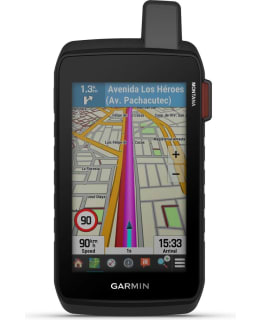
DURABLE 5-INCH TOUCHSCREEN DISPLAY
The rugged, waterproof handset is tested to MIL-STD 810 for heat, shock, water and vibration resistance. It features a 5-inch touchscreen that can be used with a gloved hand. The device is compatible with a wide range of mounting brackets (optional).
TOPOACTIVE MAPS
Pre-loaded TopoActive maps of Europe are suitable for terrain navigation. Global maps available as an optional download via Wi-Fi. Includes elevation curves, landforms, coastlines, rivers, geographical features, etc.
OUTDOOR MAPS+ SUBSCRIPTION
With a paid subscription to Outdoor Maps+, you get access to a wide range of premium maps from around the world. Maps are updated regularly and can be downloaded directly to your compatible Garmin device via Wi-Fi®.
DURATION OF THE BATTERY
Using the rechargeable lithium-ion battery pack, your device's battery lasts up to 24 hours in GPS mode on a single charge. In Expedition mode, a low-power GPS mode, Montana's battery lasts up to 432 hours on a single charge.
SATELLITE IMAGES
Free, crisp satellite images can be downloaded directly to your device via Wi-Fi® connection. You'll get a bird's-eye view and can create waypoints based on landmarks.
GARMIN RESPONSESM
In the event of an emergency, you can send an interactive SOS message to the Garmin Response Centre, where staff coordinate international rescue operations around the clock. To use, you need an active inReach® subscription and a Montana 710i.
GARMIN EXPLORETM APP
The Montana can be paired with the Garmin Explore app for route planning, route data review, and management of waypoints, routes and activities.
MULTI-SATELLITE SYSTEM SUPPORT
GPS and GALILEO satellites provide positioning in more demanding environments than GPS alone.
LOCATION SHARING1
With real-time location tracking, nearby people can track your location when your device is paired with your smartphone. When your Montana 710i has an active inReach subscription, a live tracking page is available so your followers can follow your progress, ping your device to see your GPS location and exchange messages with you.
ACCESS TO INREACH WEATHER DATA
The inReach weather service delivers accurate weather updates directly to your Montana handheld. You'll always know what weather conditions to expect along the way (inReach subscription required).
CITY NAVIGATOR MAPS
Move seamlessly from trails to city streets with the preloaded City Navigator map, featuring easy-to-understand translation-to-translation navigation.
GREATER MEMORY
32 GB of memory to load more maps for outdoor activities, including BlueChart® g3 marine maps (optional).
ABC SENSORS
ABC sensors include an altitude sensor for altitude data, a barometric pressure sensor for weather data and a triaxial electronic compass.
ACTIVE WEATHER DATA
When paired with a compatible smartphone, you can see real-time weather forecasts in the Garmin Connect™ app
DOG TRACKING
The Montana 700 Series can be paired with a compatible Alpha® Series handheld (optional) for dog tracking.
USB-C
Charging is easy with the standard USB-C® cable.
VEHICLE RACKS
With a variety of compatible mounts (optional), the Montana 700 Series can be used on an ATV, boat, car, truck, motorcycle, motorhome or other vehicle.
1An active satellite subscription is required. The use of satellite communication equipment is restricted or prohibited in some areas. It is the responsibility of the user to know and comply with the legislation in force in the area where the device is used.
2An active satellite subscription is required to use the live monitoring and messaging features of the Iridium satellite network, including SOS messages.
3For more information, visit Garmin.com/waterrating.
In the box:
- Montana® 710i
- Powerful lithium-ion battery
- USB cable (USB-C to USB-C)
- Guides