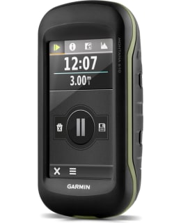
The Montana® 610 handheld device has a two-way 4-inch color touch screen that can also be used with gloves on. The user always knows where he is going, because the device shows the route trace on a map base. The device comes with a one-year BirdsEye Satellite Imagery subscription. The Montana 610 has a three-axis compass, barometric altimeter and GPS/GLONASS satellite connection for more accurate and faster positioning. The highly sensitive GPS maintains the satellite connection even in very rough terrain. The device is preloaded with 250,000 geocaches (geocaching.com). Wireless sharing of waypoints, routes, tracks and geocaches to compatible Garmin GPS devices. Bumps, moisture or water do not hinder the durable Montana 610, which is waterproof to IPX7.
The most significant changes to the previous model: GLONASS, larger internal memory (3 GB), 250,000 preloaded geocaches, Birds Eye images - subscription for one year, new Track manager function/page makes it easier to save tracks & routes.
Package contents: Montana 610, basic map, USB cable, mains charger, Li-ion battery set, user manual
• Screen size: 10.2 cm diameter
• Screen resolution: 272 x 480 pixels
• Battery/battery: Rechargeable Lithium ion (in the package) or 3 AA batteries
• Battery life: Up to 16 hours (lithium ion), up to 22 hours (AA batteries)
• Waterproof: IPX72
• Connection: High-speed USB and NMEA 0183 compatible
• Memory card slot: Yes - microSD card (not included)
• Waypoints: 4000
• Routes: 200
• Trace log: 10000 points, 200 recorded traces
• Weight: 289g with lithium-ion battery pack, 333g with three AA batteries (not included)
• Dimensions: 7.48 x 14.42 x 3.64 cm