The new ECHOMAP™ Ultra 2 chartplotter. The device features a 12-inch IPS touchscreen and physical buttons. Garmin Navionics+™ charts are available as an optional accessory, and you can purchase a one-year subscription for daily updates. The device supports LiveScope™, ClearVü™, and SideVü™ scanning sonars, as well as traditional CHIRP sonar. Via wired and wireless connections, sonar, waypoint, and route data can be shared with another ECHOMAP Ultra 2 or ECHOMAP UHD2 chartplotter on the boat (data from the LiveScope sonar, sold as an accessory, cannot be shared wirelessly). The chartplotter features Quickdraw Contours software. It supports paid map updates for Garmin Navionics Vision+™ maps and features high-resolution depth shading. When a Force® bow thruster is connected wirelessly to the chartplotter, you can create and track routes, navigate to waypoints, adjust speed, and more.
MULTI-FREQUENCY GPS
Multi-frequency GPS with fast 10 Hz updates improves positioning accuracy and signal reception, especially in areas where GPS signals are reflected or weak.
WIRELESS CONNECTIVITY
Wireless connectivity allows for the wireless sharing of sonar data, waypoints, and routes from one ECHOMAP UHD2 or ECHOMAP Ultra 2 chartplotter to another.
EASIER TO USE
The ECHOMAP Ultra 2 chartplotter features an even more user-friendly interface with a modern operating system, updated graphics, and new menus and access
SCREEN RECORDING
The screen recording feature is used via the ActiveCaptain® app downloaded to a compatible smartphone. This feature takes a screenshot of the chartplotter screen; the recording feature can also be used to capture and share a screenshot of your catch (including a LiveScope™ sonar image, if a sonar is installed).
IPS DISPLAY
The 12-inch IPS touchscreen, which also features buttons, provides all the tools you need to find and catch fish.
FORCE® BOW MOTOR INTEGRATION
Wirelessly connect to a Force bow motor to create and track routes, navigate to waypoints, adjust speed, check battery life, and more.
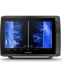
HIGH-DEFINITION SONAR IMAGES
With the GT56 transducer included with select models, you get traditional Garmin CHIRP sonar as well as Ultra High-Definition ClearVü™ and SideVü™ sonar, which provide near-photographic-quality images of the area below and to the sides of the boat.
COMPATIBLE WITH LIVESCOPE SONAR
See fish in real time with the optional LiveScope scanning sonar.
MAPS
Supports Garmin Navionics+ and Garmin Navionics Vision+ maps, available with a one-year subscription, as well as Auto Guidance+™ technology1.
BRIGHT COLORS
Identifying underwater objects and structures is easy thanks to the vivid color combinations of the scanning sonars.
QUICKDRAW CONTOURS FEATURE
Quickdraw Contours mapping software creates custom fishing maps directly from the on-screen display while you fish.
ACTIVECAPTAIN® MOBILE APP
Via Wi-Fi®, the device can be paired with the free ActiveCaptain app and the OneChart™ feature, which allows you to purchase and download new maps; Wi-Fi® connectivity also provides smart notifications2, software updates, Garmin Quickdraw™ community data, etc.
NMEA 2000® NETWORK
NMEA 2000 network available for autopilot, Fusion® audio system, engine data, digital switches, etc.
MOUNTING
Quick-release docking station speeds up mounting and removal of the device.