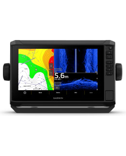
The best fishing spots, popular with locals, can be found with the help of the ECHOMAP™ UHD2 chartplotter equipped with a touch screen and buttons. The details appear even more precisely and clearly on the bright screen. The traditional Garmin sonar image shows clear and sharp fish arches. The clear color combinations of the ClearVü and SideVü™ scanning sonar help distinguish fish and targets below the boat more precisely. The ECHOMAP UDH2 also supports the LiveScope™ sonar system. Garmin Navionics+™ maps are available as an additional accessory for the device, for which you can purchase a one-year subscription for daily downloadable updates. Via the device's Wi-Fi® connection, sonar, waypoint and route data can be wirelessly shared with another ECHOMAP UHD2 chartplotter. When a compatible smartphone is paired with the free all-in-one ActiveCaptain® application, the OneChart™ feature, software updates, etc. are available. Thanks to the multi-frequency GPS, the position accuracy is even better even in areas where the GPS signals are weak or reflected. The chartplotter can be paired with the free ActiveCaptain® app downloaded to a compatible smartphone and access OneChart™ functionality, software updates, etc. The chartplotter supports NMEA 2000® networking to connect compatible autopilots, digital switches, music devices and more to the same screen.
DISPLAY
Clear and easy-to-use touch screen, which also has buttons
MORE DETAILED DISPLAY
In the 9-inch device, the screen resolution (1024 x 600) is better than before
ULTRA HIGH-DEFINITION SOUND SOUNDER
You can see under the boat with a traditional Garmin sonar and ClearVü™ and SideVü™ scanning sonar in bright color combinations. Compatible with the scanning LiveScope™ sonar
WIRELESS NETWORK
Wi-Fi® connection for wireless sharing of sonar data, waypoints and routes from one ECHOMAP UHD2 chartplotter to another
ADDITIONAL MAPS
You can get very comprehensive and detailed maps Garmin Navionics+ maps or Garmin Navionics Vision premium maps with depth shading, satellite images, Auto Guidance+1 and much more. A one-year subscription to the maps is available for daily downloadable updates.
MULTI-FREQUENCY GPS
Multi-frequency GPS uses multiple frequencies to improve location accuracy, especially in areas where GPS signals are reflected or weak
SYSTEM EXPANSION
Supports wired NMEA 2000® network connection
ACTIVECAPTAIN® APPLICATION
The chartplotter can be paired with the free ActiveCaptain® app downloaded to a compatible smartphone and access OneChart™ functionality, software updates, etc.
COMPATIBLE WITH BOW ENGINE
Can be wirelessly connected to the Force® bow motor and create and track routes, navigate to waypoints, adjust speed, check battery life, etc.
1Auto Guidance+ is for planning purposes only. It cannot replace safe navigation measures
Product length/depth: 52.8cm Product width: 34.8cm Product height: 20.1cm